| Isfahan (اصفهان) | ||
|---|---|---|
| city | ||
| Ancient names: Spadana, Spahān | ||
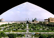
 Montage of Isfahan, Top upper left:Khaju Bridge, Top lower left:Si-o-se Pol(33 Arches Bridge), Top right:Chehel Sotun garden and palace, Bottom upper left:Naqsh-e-Jahān Square, Bottom lower left:Sheikh Lotf Allah Mosque in Ghal-e Tabarok area, Bottom right:Jameh Mosque in Shahahan area |
||
|
||
| Nickname(s): Nesf-e Jahān (Half of the world) | ||
 Isfahan |
||
| Coordinates: 32°38′N 51°39′E / 32.633°N 51.650°ECoordinates: 32°38′N 51°39′E / 32.633°N 51.650°E | ||
| Country | ||
| Province | Isfahan | |
| County | Isfahan | |
| District | Central | |
| Government | ||
| • Mayor | Morteza Saqaeian Nejad | |
| Area | ||
| • Total | 280 km2 (110 sq mi) | |
| Elevation | 1,590 m (5,217 ft) | |
| Population (2012) | ||
| • Total | 1,908,968 | |
| • Population Rank in Iran=3rd | 3rd | |
| Population Data from 2011 Census[1] |
||
| Time zone | IRST (UTC+3:30) | |
| • Summer (DST) | IRDT March 21 – September 20 (UTC+4:30) | |
| Website | www.Isfahan.ir | |
Isfahan (Persian: اصفهان Esfāhān ![]() pronunciation (help·info)), historically also rendered in English as Ispahan, Sepahan or Hispahan, is the capital of Isfahan Province in Iran, located about 340 kilometres (211 miles) south of Tehran. It has a population of 1,583,609 and is Iran's third largest city after Tehran and Mashhad. The Greater Isfahan Region had a population of 3,793,101 in the 2011 Census, the second most populous metropolitan area in Iran after Tehran.[2]
pronunciation (help·info)), historically also rendered in English as Ispahan, Sepahan or Hispahan, is the capital of Isfahan Province in Iran, located about 340 kilometres (211 miles) south of Tehran. It has a population of 1,583,609 and is Iran's third largest city after Tehran and Mashhad. The Greater Isfahan Region had a population of 3,793,101 in the 2011 Census, the second most populous metropolitan area in Iran after Tehran.[2]
The cities of Zarrinshahr, Fooladshahr and Najafabad, Se-deh, Shahin-shahr, Mobarakeh, Falavarjan and Charmahin all constitute the metropolitan city of Isfahan.
Isfahan is located on the main north-south and east-west routes crossing Iran, and was once one of the largest cities in the world. It flourished from 1050 to 1722, particularly in the 16th century under the Safavid dynasty, when it became the capital of Persia for the second time in its history. Even today, the city retains much of its past glory. It is famous for its Islamic architecture, with many beautiful boulevards, covered bridges, palaces, mosques, and minarets. This led to the Persian proverb "Esfahān nesf-e jahān ast" (Isfahan is half of the world).[3]
The Naghsh-e Jahan Square in Isfahan is one of the largest city squares in the world and an outstanding example of Iranian and Islamic architecture. It has been designated by UNESCO as a World Heritage Site. The city also has a wide variety of historic monuments and is known for the paintings and history.
Contents
[hide]
History[edit]
Prehistory[edit]
The history of Isfahan can be traced back to the Palaeolithic period. In recent discoveries, archaeologists have found artifacts dating back to the Palaeolithic, Mesolithic, Neolithic, Bronze and Iron ages.
Pre-Islamic era[edit]
| This section does not cite any references or sources. (December 2012) |
The city emerged gradually over the course of the Elamite civilization (2700 - 1600 BCE) under the name of Aspandana also spelt Ispandana. During the Median dynasty, this commercial entrepôt began to show signs of a more sedentary urbanism, steadily growing into a noteworthy regional center that benefited from the exceptionally fertile soil on the banks of the Zayendehrud River. Once Cyrus the Great (reg. 559 - 529 BCE) unified Persian and Median lands into the Achaemenid Empire (648 - 330 BCE), the religiously and ethnically diverse city of Isfahan became an early example of the king's fabled religious tolerance. The Parthians (250 BCE - 226 CE) continued this tradition after the fall of the Achaemenids, fostering the Hellenistic dimension within Iranian culture and political organization introduced by Alexander's invading armies. Under the Parthians, Arsacid governors administered a large province from Isfahan, and the city's urban development accelerated to accommodate the needs of a capital city. The next empire to rule Persia, the Sassanids (226 - 652 CE), presided over massive changes in their realm, instituting sweeping agricultural reform and reviving Iranian culture and the Zoroastrian religion. The city was then called by the name Spahān in Middle Persian. The city was governed by "Espoohrans" or the members of seven noble Iranian families who had important royal positions, and served as the residence of these noble families as well. Extant foundations of some Sassanid-era bridges in Isfahan suggest that the kings were also fond of ambitious urban planning projects. While Isfahan's political importance declined during the period, many Sassanian princes would study statecraft in the city, and its military role developed rapidly. Its strategic location at the intersection of the ancient roads to Susa and Persepolis made it an ideal candidate to house a standing army, ready to march against Constantinople at any moment. One etymological theory argues that the name 'Aspahan' derives from the Pahlavi for 'place of the army.'[4]
Persia's Capital[edit]
In 1598 Shah Abbas the Great moved his capital from Qazvin to the more central and Persian Isfahan, called Ispahān in early New Persian. This new importance ushered in a golden age for the city which lasted until it was sacked by Afghan invaders in 1722. The capital subsequently moved several times until settling in Tehran in 1795.[citation needed]
Modern age[edit]
Today Isfahan, the third largest city in Iran, produces fine carpets, textiles, steel, and handicrafts. Isfahan also has nuclear experimental reactors as well as facilities for producing nuclear fuel (UCF). Isfahan has one of the largest steel-producing facilities in the entire region, as well as facilities for producing special alloys.[citation needed]
The city has an international airport and is in the final stages of constructing its first Metro line.
Over 2000 companies are working in the area using Isfahan's economic, cultural, and social potentials. Isfahan contains a major oil refinery and a large airforce base. HESA, Iran's most advanced aircraft manufacturing plant (where the IR.AN-140 aircraft is made), is located nearby.[5]
Isfahan hosted the International Physics Olympiad in 2007.
Geography and climate[edit]
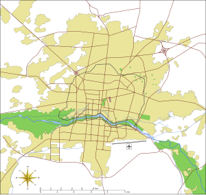
The city is located in the lush plain of the Zayandeh River, at the foothills of the Zagros mountain range. No geological obstacles exist within 90 kilometres (56 miles) north of Isfahan, allowing cool northern winds to blow from this direction. Situated at 1,590 metres (5,217 ft) above sea level on the eastern side of the Zagros Mountains, Isfahan has an arid climate (Köppen BWk). Despite its altitude, Isfahan remains very hot during the summer with maxima typically around 36 °C (97 °F). However, with low humidity and moderate temperatures at night, the climate can be very pleasant. During the winter, days are mild while nights can be very cold. Snow has occurred at least once every winter except 1986/1987 and 1989/1990.[6][7]
| [hide]Climate data for Isfahan | |||||||||||||
|---|---|---|---|---|---|---|---|---|---|---|---|---|---|
| Month | Jan | Feb | Mar | Apr | May | Jun | Jul | Aug | Sep | Oct | Nov | Dec | Year |
| Record high °C (°F) | 20 (68) |
23 (73) |
27 (81) |
32 (90) |
33.6 (92.5) |
35.2 (95.4) |
37.7 (99.9) |
37.0 (98.6) |
35 (95) |
33.2 (91.8) |
25.5 (77.9) |
21.2 (70.2) |
37.7 (99.9) |
| Average high °C (°F) | 9.2 (48.6) |
12.5 (54.5) |
17.0 (62.6) |
22.7 (72.9) |
28.2 (82.8) |
32.3 (90.1) |
34.7 (94.5) |
33.6 (92.5) |
30.8 (87.4) |
25 (77) |
17 (63) |
11 (52) |
23.42 (74.16) |
| Average low °C (°F) | −2.5 (27.5) |
−0.4 (31.3) |
4.1 (39.4) |
9.3 (48.7) |
13.7 (56.7) |
18.5 (65.3) |
21.0 (69.8) |
19.1 (66.4) |
14.7 (58.5) |
8.9 (48) |
3.2 (37.8) |
−1 (30) |
9.05 (48.29) |
| Record low °C (°F) | −19.4 (−2.9) |
−12.2 (10) |
−6.2 (20.8) |
−4 (25) |
4.5 (40.1) |
10 (50) |
13 (55) |
11 (52) |
5 (41) |
0 (32) |
−8 (18) |
−13 (9) |
−19.4 (−2.9) |
| Precipitation mm (inches) | 29.9 (1.177) |
40.0 (1.575) |
31.7 (1.248) |
28.9 (1.138) |
18.7 (0.736) |
11.2 (0.441) |
6.7 (0.264) |
2.3 (0.091) |
2.1 (0.083) |
13.9 (0.547) |
22.5 (0.886) |
29.7 (1.169) |
237.6 (9.355) |
| Avg. precipitation days (≥ 1.0 mm) | 4.1 | 6.0 | 4.1 | 3.4 | 2.5 | 1.7 | 1.0 | 0.8 | 0.8 | 1.7 | 3.3 | 3.9 | 33.3 |
| % humidity | 60 | 65 | 53 | 60 | 44 | 35 | 25 | 26 | 28 | 38 | 50 | 70 | 46.2 |
| Mean monthly sunshine hours | 203.6 | 216.8 | 243.7 | 250.0 | 308.7 | 348.3 | 349.4 | 339.7 | 311.3 | 281.5 | 224.2 | 197.0 | 3,274.2 |
| Source: Synoptic Stations Statistics | |||||||||||||
Main sights[edit]


Bazaars[edit]
- Shahi Bazaar - 17th century
Bridges[edit]
The Zayande River starts in the Zagros Mountains, flows from west to east through the heart of Isfahan, and dries up in the Kavir desert.
The bridges over the river include some of the finest architecture in Isfahan. The oldest bridge is the "Pol-e Shahrestan", which was probably built in the 1100s during the Seljuk period.[citation needed] Further upstream is the "Pol-e Khaju", which was built by Shah Abbas II in 1650. It is 123 metres long with 24 arches, and also serves as a sluice gate.
The next bridge is the "Pol-e Jubi". It was originally built as an aqueduct to supply the palace gardens on the north bank of the river. Further upstream again is the Si-o-Seh Pol or bridge of 33 arches. Built during the rule of Shah Abbas the Great, it linked Isfahan with the Armenian suburb of Jolfa. It is by far the longest bridge in Isfahan at 295 m (967.85 ft).
Other bridges include:
- Pol-e Shahrestan (The Shahrestan bridge)
- Marnan Bridge
- Pol-e Khaju (Khaju Bridge) – 1650.
- Si-o-Seh Pol (The Bridge of 33 Arches) – 1602.
- Pol-e-Joui or Choobi (Joui bridge). - 1665
Churches and cathedrals[edit]
- Bedkhem Church - 1627
- St. Georg Church - 17th century
- St. Mary Church - 17th century
- Vank Cathedral – 1664
Emamzadehs[edit]
- Emamzadeh Ahmad
- Emamzadeh Esmaeil, Isfahan
- Emamzadeh Haroun-e-Velayat - 16th century
- Emamzadeh Jafar
- Emamzadeh Shah Zeyd
Houses[edit]
- Alam's House
- Amin's House
- Malek Vineyard
- Qazvinis' House - 19th century
- Sheykh ol-Eslam's House
Mausoleums and Tombs[edit]
- Al-Rashid Mausoleum - 12th century
- Baba Ghassem Mausoleum - 14th century
- Mausoleum of Safavid Princes
- Nizam al-Mulk Tomb - 11th century
- Saeb Mausoleum
- Shahshahan mausoleum - 15th century
- Soltan Bakht Agha Mausoleum - 14th century
Minarets[edit]
- Ali minaret - 11th century
- Bagh-e-Ghoushkhane minaret - 14th century
- Chehel Dokhtaran minaret - 12 century
- Dardasht minarets - 14th century
- Darozziafe minarets - 14th century
- Menar Jonban - 14th century
- Sarban minaret
Mosques[edit]
- Agha Nour mosque - 16th century
- Hakim Mosque
- Ilchi mosque
- Jameh Mosque[8]
- Jarchi mosque - 1610
- Lonban mosque
- Maghsoudbeyk mosque - 1601
-
نظرات شما عزیزان:

 آمار
وب سایت:


